Summary of the 2024 Noto Peninsula Earthquake: Impact on Toyama Prefecture and Future Preparedness
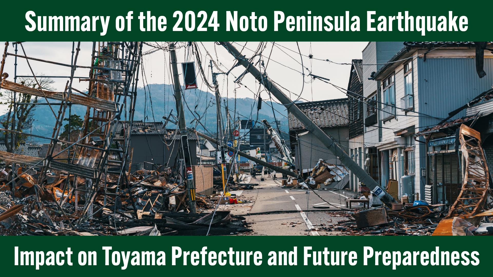
The Noto Peninsula Earthquake that struck on January 1, 2024, caused significant damage, primarily in the Noto region of Ishikawa Prefecture. The epicenter was located near Suzu City, Ishikawa, and the earthquake is estimated to have had a magnitude of 7.6.
In this article, we provide a detailed summary of the damage caused by the earthquake across the affected regions, using various data sources. Special emphasis is placed on the impact within Toyama Prefecture.
Toyama experienced severe shaking, with the maximum seismic intensity recorded at upper 5 on the Japanese Shindo scale. While the damage was substantial, the possibility of an even larger earthquake occurring in the future cannot be ruled out.
In preparing for future seismic events, two key considerations emerge:
- What lessons have we learned from this earthquake?
- Based on those lessons, what actions must we take to protect lives during a future major earthquake?
By understanding the damage caused by the 2024 Noto Peninsula Earthquake, we can better prepare for future disasters.
・・・・・
Overview of the 2024 Noto Peninsula Earthquake
Magnitude and Epicenter
At 16:10 on January 1, 2024, a major earthquake struck the Noto region of Ishikawa Prefecture. The quake registered a magnitude of 7.6 and a maximum intensity of 7 on the Shindo scale. It was the strongest earthquake in Japan's observational history originating from an active fault.
The epicenter was along an active fault extending from the western offshore area of the Noto Peninsula to the west of Sado Island, with an estimated fault length of approximately 150 km.
Seismic Intensity Across Japan
The earthquake produced a seismic intensity of 7 in Wajima City and Shika Town, with widespread shaking of upper and lower 6 throughout the broader Noto region. The tremors were felt across a vast area, from Hokkaido to Kyushu, with intensities ranging from upper 6 to 1.
Multiple large aftershocks occurred before and after the main quake, resulting in prolonged and intense shaking.
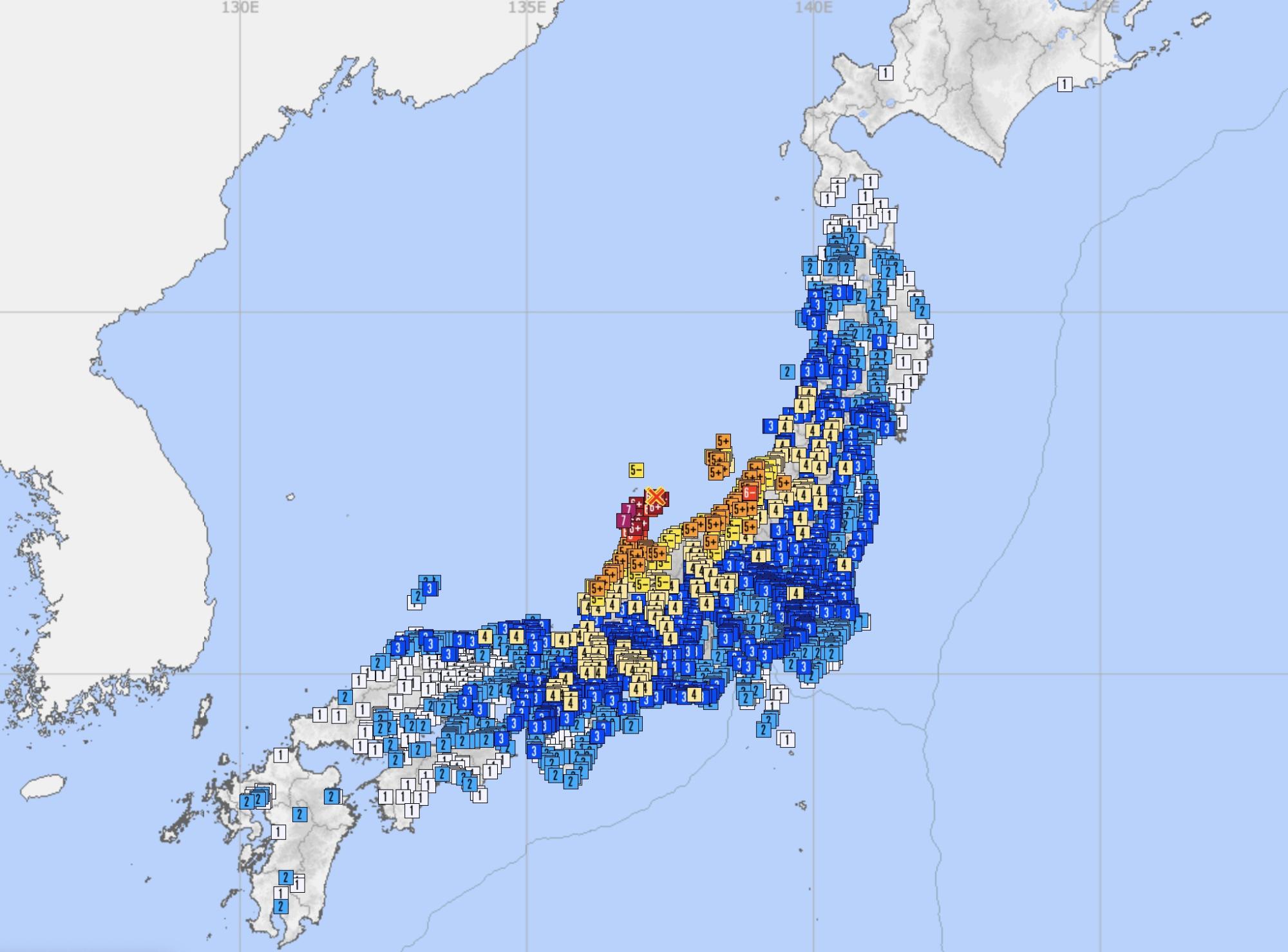
Source: Japan Meteorological Agency – Seismic Intensity Database
Seismic Intensity in Toyama Prefecture
Municipalities throughout Toyama Prefecture recorded intensities ranging from upper 5 to 4.
For the first time in recorded history, an upper 5 intensity was observed in Toyama City, Takaoka City, Himi City, Oyabe City, Nanto City, Imizu City, and Funahashi Village. For many residents, the intensity of the shaking was unprecedented.

Source: Japan Meteorological Agency – Seismic Intensity Database
Observed Seismic Intensity in Toyama Prefecture
The seismic intensities recorded at observation points throughout Toyama Prefecture are as follows.
| Seismic Intensity | Observation Sites |
|---|---|
| Upper 5 | Toyama City (Shinsakuramachi), Takaoka City (Fushiki), Himi City (Kano), Oyabe City (Izumicho, Mizumaki), Nanto City (Hebigui), Imizu City (Kuguminato, Kojima, Honmachi, Hashimojo, Futakuchi, Kamo Chubu), Funahashi Village (Busshoji) |
| Lower 5 | Toyama City (Ishizaka, Yatsuo-Fukushima, Fuchu-Sasakura), Takaoka City (Hirokoji, Fukuoka), Namerikawa City (Jikecho), Kurobe City (Ueki), Tonami City (Sakaemachi, Shogawamachi), Nanto City (Amaike, Araki, Johana, Shimonashi, Kamihira-Hosojima, Inami, Naejima), Kamiichi Town (Hieda), Tateyama Town (Yoshimine, Ashikuraji), Asahi Town (Michishita) |
| 4 | Toyama City (Imaizumi, Hanasaki, Kaminisugi, Yamadayu, Nirehara), Uozu City (Shakado, Honjo), Kurobe City (Unazuki-Shimodate), Tateyama Town (Yonezawa), Nyuzen Town (Nyūzen), Asahi Town (Sakai), Nanto City (Togamura Kamihyakumose) |
・・・・・
Crustal Deformation
Record-Setting Coastal Uplift
One of the defining features of the 2024 Noto Peninsula Earthquake was the occurrence of significant coastal uplift.
Such uplift typically results from earthquakes with epicenters located in offshore areas close to land. According to the Geospatial Information Authority of Japan (GSI), the seabed along the coast - stretching approximately 90 km from Suzu City through Wajima City to Shika Town - was uplifted. In western Wajima City, the vertical displacement reached approximately 4 meters, marking the largest coastal uplift ever recorded in Japan.

Image source: Geological Survey of Japan, AIST – Fourth Report on Emergency Survey of Coastal Uplift, 2024 Noto Peninsula Earthquake
Geological strata in the Noto Peninsula show evidence of repeated coastal uplift events in the past, likely triggered by previous earthquakes. In fact, the very formation of the peninsula can be understood as the cumulative result of repeated uplifts over the course of Earth’s geological history.
This time, due to the uplift, large sections of what was previously seabed along the peninsula’s coastline became land. The red areas on the map below represent these newly exposed coastal regions, stretching extensively from Suzu City to Shika Town.

Source: Geospatial Information Authority of Japan
Damage to Fishing Ports from Coastal Uplift
As a result of the uplift, many fishing ports along the western coast of the Noto Peninsula became non-operational due to shallower waters or exposed seabeds, making it impossible for vessels to launch.
According to the Ishikawa Prefectural Government, 23 ports—22 fishing ports and 1 general port—sustained damage caused by uplift. These ports serve as critical hubs for logistics during disaster response, and their dysfunction posed a serious challenge to recovery efforts in the affected areas.
Furthermore, there have been reports of declining fish catches and disrupted marine ecosystems due to the uplift, significantly impacting Ishikawa Prefecture’s fishing industry, one of its major economic sectors.
No Coastal Uplift Observed in Toyama Prefecture
As of now, there have been no reports of coastal uplift in Toyama Prefecture resulting from the Noto Peninsula Earthquake.
This is consistent with the fact that uplift occurred predominantly on the northwestern side of the Noto Peninsula, pushing outward toward the sea. Toyama Prefecture lies to the southeast of the peninsula, where no uplift was observed.
However, because Toyama faces the sea, a future earthquake with an epicenter off the Toyama coastline could potentially cause similar coastal uplift. Should that occur, there is a risk of serious disruptions to port functions and negative impacts on the fishing industry.
・・・・・
Tsunami
Widespread Tsunami and Inundation Damage
Tsunamis triggered by the Noto Peninsula Earthquake reached various coastal areas.
A key characteristic of these tsunamis was the extremely short time between the earthquake and the arrival of the first wave. This rapid onset was due to the proximity of the epicenter to the land.
In Suzu and Wajima cities in Ishikawa Prefecture, the first wave arrived within one minute of the earthquake. In Nanao City, it arrived in approximately two minutes.
Inundation due to tsunamis occurred over a wide area of the peninsula.
The blue zones on the map below indicate regions affected by tsunami flooding.
Around Ukai Fishing Port in Suzu City—the area most heavily inundated—wave run-up heights exceeded 3 meters, and buildings were flooded to depths of over 2.5 meters.
(Source: Prof. Shunichi Koshimura, International Research Institute of Disaster Science, Tohoku University)
Aerial image analysis later estimated tsunami inundation up to 500 meters inland in certain areas.

Source: Geospatial Information Authority of Japan
According to research by the Earthquake Research Institute of the University of Tokyo, tsunami run-up in Akasaki, Shika Town, Ishikawa, reached a height of 4.2 meters. These tsunami waves caused extensive damage to buildings and port facilities along the coastline of the Noto Peninsula.

Image source: Earthquake Research Institute, University of Tokyo – Research Bulletin, 2024 Noto Peninsula Earthquake

Image source: “More Ishikawa” – Ishikawa Prefecture Government
Tsunami Damage in Toyama Prefecture
First Wave Reached Toyama Only Three Minutes After the Earthquake
In Toyama Prefecture, a tsunami warning was issued shortly after the earthquake, and tsunami waves were subsequently observed along its coast.
Despite being relatively far from the epicenter, Toyama City was reached by the first tsunami wave within three minutes, and Takaoka City within two minutes. This is notably faster than in Nanao Port, Ishikawa, which saw the first wave 37 minutes post-quake—suggesting that some parts of Toyama Bay experienced localized, rapid tsunami impact.
A later investigation by the Japan Coast Guard revealed a submarine slope collapse off the coast of Toyama Bay. This collapse is believed to have generated localized tsunami waves along the bay’s coastal regions.
This event underscores the importance of recognizing that tsunamis can also be triggered by underwater landslides, not just seismic epicenters. Even when the earthquake occurs far offshore, immediate evacuation from coastal areas remains essential.
Maximum 2-Meter Tsunami Along the Himi Coast
Let’s look at recorded tsunami heights along the Toyama coastline.
At the tide station in Toyama City, waves up to 80 cm were observed. A field survey by the Japan Meteorological Agency confirmed a wave run-up height of 1.5 meters in Kairyushinmachi, Imizu City.
Further research by Associate Professor Shuichi Go of Toyama Prefectural University and Associate Professor Anawat Suppasri of the International Research Institute of Disaster Science, Tohoku University, confirmed a maximum wave run-up height exceeding 2 meters along the Himi coast.

Source: Japan Meteorological Agency – Tsunami Heights and Inundation Depths at Tide Stations
Chaos Caused by Toyama’s First-Ever Tsunami Warning
The tsunami warning issued for Toyama Prefecture was the first in 31 years, since the 1993 Southwest Hokkaido Earthquake.
The warning prompted a large number of residents near the coast to evacuate to higher ground, which led to confusion and disruptions. According to a survey conducted by NHK on February 2, 2024, more than half of the evacuees used vehicles, resulting in reports of traffic congestion and impassable roads due to liquefaction or uplift.
A Yomiuri Shimbun article noted that in Uozu City, despite efforts to promote evacuation on foot during routine disaster drills, many residents evacuated by car amid the confusion. This led to severe traffic jams as calls via emergency broadcast systems could not be issued in time.
(Source: Yomiuri Shimbun, February 2 – “Massive Traffic Jams During Tsunami Evacuation: 'Evacuate on Foot' Message Not Delivered in Time” by Koichiro Yoshitake)
Other issues reported across the prefecture included:
・ Congestion at shelters due to evacuations from areas not at risk of flooding.
・ People rushing to evacuation sites outside their own municipality in an attempt to flee as far as possible.
These events revealed serious challenges in Toyama’s tsunami preparedness and response.
The 2011 Great East Japan Earthquake taught us that people stuck in traffic during evacuations suffered devastating losses. As a result, many municipalities now stipulate in their disaster plans that tsunami evacuations should be carried out on foot. In Toyama Prefecture as well, walking is the default method of evacuation—except in cases involving elderly or disabled individuals who require vehicular transport.
The confusion experienced during this event highlights the urgent need to reevaluate evacuation routes and methods in preparation for future tsunami threats.

Japan Meteorological Agency – Tsunami Warning issued at 16:22 on January 1
・・・・・
Liquefaction
Widespread Liquefaction Triggered by the Noto Peninsula Earthquake
According to a survey conducted by the National Research Institute for Earth Science and Disaster Resilience (NIED), the 2024 Noto Peninsula Earthquake caused liquefaction across a broad area spanning four prefectures - Ishikawa, Toyama, Fukui, and Niigata - and a total of 34 municipalities.
Liquefaction is a phenomenon in which saturated sandy soil temporarily loses its strength and stiffness in response to intense ground shaking. During such events, sand grains are suspended in groundwater, turning the soil into a slurry-like state.
A typical symptom of liquefaction is the sand boil phenomenon, where water and sand are ejected from the ground. The ground also loses its ability to support structures: heavier objects such as buildings and bridges may sink, while lighter underground structures such as pipes and manholes may be forced upward by buoyant forces.

Image source: NIED, “Distribution and Characteristics of Liquefaction Damage from the 2024 Noto Peninsula Earthquake,” by Shigeki Sakina

What is liquefaction? (Source: Ministry of Land, Infrastructure, Transport and Tourism)
Liquefaction causes severe damage not only to buildings, roads, and water infrastructure, but also leads to sloped or sunken residential land.
Although the total number of confirmed liquefaction sites in this event (2,114) was fewer than that of the 2011 Great East Japan Earthquake (8,680), it exceeded the number recorded during the 2016 Kumamoto Earthquake (1,890) and the 1995 Great Hanshin-Awaji Earthquake (1,266).
Why did the Noto Peninsula Earthquake result in such widespread liquefaction? Let’s examine the key contributing factors.

Liquefaction damage in Uchinada Town, Ishikawa Prefecture (Source: Ishikawa Prefecture "More Ishikawa")
Reason 1: Sandy Soils Such as Dunes and Reclaimed Land
Two main conditions make land susceptible to liquefaction:
- The presence of high groundwater levels
- Loosely deposited sandy soil
Along the Sea of Japan coast, seasonal northwesterly winds carry and deposit sand onto the shore, creating dunes. Many of the areas that experienced liquefaction in this event were classified as dune regions.
In addition, coastal and riverside areas typically have high groundwater tables and moisture-rich sediment layers.
Since the quake caused strong shaking in coastal prefectures like Ishikawa, Toyama, Niigata, and Fukui—many of which have extensive sandy terrain and reclaimed land—widespread liquefaction was inevitable.
Reason 2: Prolonged Strong Shaking
Another major factor was the duration of the shaking.
NIED’s analysis shows that 16% of liquefaction sites from this earthquake were in areas with seismic intensities of 5-lower or less on the Shindo scale. By comparison, only 4% of liquefaction sites during the Great East Japan Earthquake and 1% during the Kumamoto Earthquake were in similarly low-intensity areas.
While intense shaking is a prerequisite for liquefaction, its duration also plays a critical role. The Kumamoto Earthquake featured about 10 seconds of strong shaking, whereas the Noto Peninsula Earthquake lasted around 40 seconds. This extended shaking likely caused liquefaction even in areas where seismic intensity was not particularly high.
Liquefaction Damage in Toyama Prefecture
In Toyama Prefecture, liquefaction occurred in various coastal areas, causing severe damage to ports, buildings, and roads due to land subsidence and tilting.
Affected municipalities included:
Himi City, Takaoka City, Imizu City, Toyama City, Namerikawa City, and Uozu City.
Here are some of the most heavily affected districts and their underlying geographical features:
Fushiki District, Takaoka City
Fushiki experienced widespread liquefaction, leading to sand boils and significant tilting of residential land.
A local survey reported that about 120 households relocated, with the Ishizaka and Nakamichi areas—where damage was most severe—seeing nearly half of their residents move out.
(Source: KNB, December 24, 2024, “Rebuilding Community in Quake-Stricken Fushiki, Takaoka City”)

Heavily liquefaction-affected area in Fushiki, Takaoka City (center of the map) (Source: Geospatial Information Authority of Japan)
Located between the Sea of Japan and the mouth of the Oyabe River, Fushiki is geologically classified as a sand spit and dune region. The hardest-hit areas were developed on low-lying wetlands reclaimed during the Edo period, and likely had high groundwater levels.
The combination of sandy ground, proximity to water bodies, and reclaimed land history created conditions ripe for liquefaction.
Yoshihisa District, Takaoka City
Yoshihisa lies across the Oyabe River from Fushiki and also suffered extensive liquefaction.

Heavily liquefaction-affected area in Yoshihisa District, Takaoka City (center of the map) (Source: Geospatial Information Authority of Japan)
A historic town that served as a rice granary during the Edo period, parts of Yoshihisa are designated as Important Preservation Districts for Groups of Traditional Buildings.
Geographically, Yoshihisa is situated on a floodplain between the Oyabe and Sho Rivers. These low-lying, flat areas were formed by sediment deposition from floods and old seabeds, which results in sandy soil and high groundwater tables.
Surveys indicate that liquefaction was most severe near the Oyabe River, while areas along the Sho River, including the preservation district, sustained comparatively lighter damage.
Yokota District, Takaoka City
Though located inland in central Takaoka and far from the coast, Yokota experienced significant liquefaction, with visible land tilting and structural damage.

Heavily liquefaction-affected area in Yokota Town, Takaoka City (around the red circle) (Source: Geospatial Information Authority of Japan)
Developed in the late 1990s by reclaiming former rice paddies, Yokota is situated on either a floodplain or an abandoned river channel. Its underlying soil likely contains water-saturated sand deposited by the nearby Senbo River.
These conditions suggest the area was highly susceptible to liquefaction despite its inland location.
Kitaomachi and Sakaemachi, Himi City
Widespread liquefaction was reported across Himi City, particularly in coastal areas like Kitaomachi, Sakaemachi, and Himimachi.

Heavily liquefaction-affected area: Sakaemachi and Kitaomachi, Himi City (Map: Geospatial Information Authority of Japan)
These districts are built on dunes and reclaimed land. The seasonal winds along the Sea of Japan coast make this region prone to sand accumulation and dune formation—soil types that are particularly vulnerable to liquefaction.
The area is also close to several river mouths (Kami-Shō River, Yogawa River, and Busshōji River), contributing to high moisture content and elevated groundwater levels.
Himi Banya-gai and Sōyu Area

Liquefaction Damage in the “Himi Banya-gai” and “Soyu” Area
Located in Kitaomachi, the Himi Banya-gai and Sōyu areas are key tourist facilities built on reclaimed land completed in 2006.
Post-earthquake, sand boils, ground cracks, and sinkholes appeared in the parking lot. Water pipe damage caused prolonged service outages, and the facilities had to suspend operations for an extended period—delivering a heavy blow to the local tourism industry.
The combination of a new landfill site and a vulnerable location made this area especially prone to liquefaction.
Tōrenmachi District, Toyama City
In the Tōrenmachi area along a canal in northern Toyama City, over 70 out of 240 homes were affected by liquefaction, with widespread subsidence and tilting.

Liquefaction Damage in the Tōrenmachi District, Toyama City
Upon examining the artificial formation of the land, it is evident that Tōrenmachi and the surrounding area fall under the category of filled or reclaimed land. This refers to land that has been artificially raised above the surrounding terrain using embankments, or created by depositing earth into bodies of water or filling in depressions such as valleys.
In this case, the liquefaction was particularly concentrated in the area marked in red on the map within Tōrenmachi. This zone corresponds to an old river channel and lies along a canal, suggesting that the ground likely contains a significant amount of deposited sand and has a high groundwater table.
Common Features of Severely Affected Areas
According to surveys by Takaoka City, all three of its most severely affected districts had high groundwater levels and loose sand layers near the surface. The presence of saturated sandy soil near the ground surface was a key factor contributing to liquefaction.
Similar conditions - such as proximity to the sea or rivers, sandy geological features, and high water tables - were also observed in other affected areas like Himi City.
While liquefaction was especially prevalent in coastal areas, it was also confirmed inland, as in Yokota District, when specific ground conditions were met.
How to Assess Liquefaction Risk in Your Area
Residents are encouraged to research their local land history and liquefaction risk using the following resources:
▶︎ GSI "Overlay Hazard Maps"
A national tool for checking disaster risks, landforms, and historical land use.
[Link]
▶︎ Hokuriku Regional Development Bureau "Liquefaction Susceptibility Map"
Provides liquefaction risk data for the Hokuriku region.
[Link]
・・・・・
Residential Damage
Number of Damaged Houses by Prefecture
The 2024 Noto Peninsula Earthquake caused damage to nearly 150,000 homes, of which approximately 30,000 were either totally or partially destroyed. Many residents were forced to evacuate and live in temporary shelters, unable to remain in their own homes.
The table below summarizes the number of damaged houses by prefecture and level of damage:
| Prefecture | Completely Destroyed | Partially Destroyed | Minor Damage | Flooded | Total |
|---|---|---|---|---|---|
| Niigata | 109 | 4,080 | 19,861 | 14 | 24,064 |
| Toyama | 259 | 805 | 21,341 | 22,405 | |
| Ishikawa | 6,077 | 18,328 | 77,990 | 11 | 102,406 |
| Fukui | 12 | 815 | 827 | ||
| Nagano | 20 | 20 | |||
| Gifu | 2 | 2 | |||
| Total | 6,445 | 23,225 | 120,029 | 25 | 149,724 |
Source: Cabinet Office, “Damage Situation from the 2024 Noto Peninsula Earthquake” (December 24, 2024)
The most severe residential damage occurred in Ishikawa Prefecture, followed by Niigata and Toyama. Within Ishikawa, damage was particularly concentrated in Wajima City, Suzu City, Shika Town, and Nanao City, all located on the Noto Peninsula.
According to data released by the Ministry of Land, Infrastructure, Transport and Tourism (MLIT), these severely affected areas shared several characteristics that likely contributed to the extent of the damage:
Common Features of Areas with Extensive Housing Damage
- A high percentage of wooden-frame houses (over 80%; national average is under 60%)
- Many homes built in earlier decades
- Especially high proportion of houses built before 1980 (over 50–60%; national average is 22.4%)
- High vacancy rates (over 20% in many municipalities; national average is 13%)
Among these, the prevalence of pre-1980 construction stands out as a significant factor. Compared to the national average of 22.4%, over half the homes in the hardest-hit areas were built before 1980.
Japan’s building codes related to seismic resistance have evolved in response to major past earthquakes. Following the 1978 Miyagi-Oki Earthquake, new seismic standards were introduced in 1981. Buildings constructed before and after this revision differ substantially in their resistance to seismic shaking.
Although many buildings were damaged in this earthquake, the large number of homes built before 1981 may have been a major contributing factor.
Interestingly, MLIT’s data also shows that the proportion of homes with preexisting deterioration or structural damage was not particularly high. This suggests that many of the damaged homes were otherwise habitable before the earthquake.
Reference: MLIT, “Residential Data for Municipalities Affected by the 2024 Noto Peninsula Earthquake”
Number of Damaged Homes in Toyama Prefecture (by Municipality)
In Toyama Prefecture, more than 22,000 homes were damaged. The table below shows the breakdown by municipality:
| Municipality | Completely Destroyed | Partially Destroyed | Minor Damage | Unclassified | Total |
|---|---|---|---|---|---|
| Toyama City | 2 | 49 | 3,433 | 18 | 3,502 |
| Takaoka City | 152 | 5,338 | 5,490 | ||
| Uozu City | 88 | 88 | |||
| Himi City | 233 | 501 | 5,968 | 6,702 | |
| Namerikawa City | 212 | 212 | |||
| Kurobe City | 241 | 2 | 243 | ||
| Tonami City | 199 | 199 | |||
| Oyabe City | 10 | 40 | 1,817 | 4 | 1,871 |
| Nanto City | 251 | 251 | |||
| Imizu City | 14 | 63 | 3,309 | 3,386 | |
| Funahashi Village | 33 | 33 | |||
| Kamiichi Town | 151 | 151 | |||
| Tateyama Town | 85 | 85 | |||
| Nyuzen Town | 73 | 73 | |||
| Asahi Town | 143 | 143 | |||
| Total | 259 | 805 | 21,341 | 26 | 22,429 |
Source: Toyama Prefecture, “Damage and Support Status from the 2024 Noto Peninsula Earthquake” (November 29, 2024)
Damage in Himi City
According to the table, Himi City experienced the highest concentration of completely and partially destroyed houses in the prefecture. It also had the largest total number of damaged homes, including those with minor damage.
Himi’s proximity to the earthquake’s epicenter and the occurrence of widespread liquefaction in coastal districts were key factors. The most severely damaged areas, such as Kitaomachi, Sakaemachi, Jizomachi, Saiwaimachi, and Himimachi, correspond to locations where liquefaction was observed.
Damage in Imizu and Takaoka Cities
In Imizu City and Takaoka City, building damage was concentrated in coastal zones. In areas like Shinminato (Imizu) and Fushiki (Takaoka), severe liquefaction occurred as a result of the Noto Peninsula Earthquake.
In liquefied zones, a large number of homes were damaged. In Takaoka’s Yokota District, even areas distant from the coast experienced land tilting and significant building damage due to liquefaction.
Damage in Oyabe City
In Oyabe City, severe residential damage—including completely and partially destroyed homes—was concentrated in the Habū and Isurugi districts.
These neighborhoods are located in hilly areas developed on embankments. Ground destabilization from the earthquake likely contributed to the collapse or deformation of homes in these areas.
・・・・・
Fires
Large-Scale Fire in Wajima City

Fire damage in Wajima City (Source: Ishikawa Prefectural Government website)
The 2024 Noto Peninsula Earthquake also triggered multiple fires.
Among them, the most devastating occurred in the Kawai-machi Asaichi-dori area of Wajima City, Ishikawa Prefecture, which recorded a seismic intensity of upper 6 on the Japanese Shindo scale. This fire destroyed approximately 240 buildings and spread across around 49,000 square meters.
The affected district, home to a traditional morning market with a history spanning over 1,000 years, was characterized by densely packed, old wooden houses with low fire resistance—a known vulnerability in terms of disaster risk.
However, the massive scale of the fire cannot be attributed solely to the density of aging wooden homes. At the time of the fire in Kawai-machi, Wajima, multiple compounding factors made firefighting efforts extremely difficult:
- Water supply was cut off due to earthquake-induced pipeline damage, rendering fire hydrants unusable.
- Underground fire water tanks were inaccessible due to building collapses.
- Water levels in nearby rivers dropped, and a major tsunami warning made drawing water from rivers or the sea unsafe or impossible.
These compounded into a critical shortage of water sources for firefighting - a highly abnormal situation. Under normal circumstances, Kawai-machi, being near the ocean and river mouths, would not have had issues securing water for fire suppression.
This event illustrates how, in the event of a major earthquake, not only is the risk of fire ignition elevated due to shaking, but firefighting activities may also be severely hindered, increasing the likelihood of large-scale destruction.
Fires in Toyama Prefecture
In Toyama Prefecture, five fire incidents were reported as a result of the 2024 Noto Peninsula Earthquake. A summary of each incident is provided below:
| Municipality | Damage Scale | Building Type | Time of Notification | Buildings Burned | Area Burned (㎡) | Casualties | Cause | Summary |
|---|---|---|---|---|---|---|---|---|
| Toyama City | Partial | Hospital | Jan 1, 18:13 | 1 | 2 | None | Shaking | Alcohol-based medical equipment reportedly fell during the quake and ignited upon contact with a heat source. |
| Small-scale | Residence | Jan 2, 08:15 | 1 | Minor | None | Heating appliance | A fallen heater came into contact with the floor, igniting a fire. | |
| Takaoka City | Partial | Factory | Jan 1, 16:31 | 1 | 19 | None | Heating equipment | Molten zinc overflowed from a furnace due to shaking, igniting part of the factory and a nearby truck. |
| Uozu City | Small-scale | Senior care facility | Jan 1, 16:21 | 1 | 0 | None | Electrical wiring | Ceiling wiring is believed to have caught fire due to earthquake-induced damage. |
| Himi City | – | Other | Jan 1, 17:07 | – | 0 | None | Electrical wiring | Seawater from the fishing port came into contact with a damaged power cable, causing a short circuit and fire. |
Causes of Earthquake-Related Fires
These incidents were caused by factors such as:
- Falling flammable materials
- Tipping of heating appliances
- Damage to electrical wiring due to strong shaking
As the Noto Peninsula Earthquake occurred during the winter season, the risk of fire was heightened by the presence of heaters and flammable household items. Items falling onto heating appliances or the heaters themselves tipping over are common ignition sources during winter earthquakes and require special attention.
Earthquake Fire Prevention: Six Key Recommendations
Japan’s Fire and Disaster Management Agency (FDMA) has identified six key measures to help prevent earthquake-related fires in residential areas. Homeowners are strongly encouraged to review these points:
Checklist to Prevent Fires During Earthquakes
- ✓ Ensure your home is structurally earthquake-resistant
- ✓ Secure furniture and appliances to prevent tipping
- ✓ Install a seismic circuit breaker
- ✓ Keep the area around stoves and heaters clear of combustible materials
- ✓ Install a household fire extinguisher and learn how to use it
- ✓ Install residential fire alarms, preferably with advanced features such as interconnectivity
(Source: FDMA, “Measures for Preventing Fires Caused by Earthquakes”)
・・・・・
Lifelines
Water Supply Disruption
The 2024 Noto Peninsula Earthquake caused widespread disruption to water services, with a total of 136,440 households experiencing water outages across the affected prefectures: Ishikawa, Toyama, Niigata, Fukui, Nagano, and Gifu.
The Ishikawa Prefectural Government announced on May 31, 2024, nearly five months after the earthquake, that water supply had been restored to all areas except those where access remained impossible due to landslides or collapsed structures.
The prolonged recovery period was attributed to several key challenges:
- Major damage to core water infrastructure, including water purification plants, distribution reservoirs, and main pipelines, which had not been seismically reinforced.
- Road closures, debris, and winter weather, which hampered access and slowed down repair operations.
- A lack of operational bases and lodging for workers, which delayed the mobilization of repair teams.
Extended loss of water and other lifeline utilities can significantly impair daily life in disaster-stricken areas and may lead to secondary human impacts, including disaster-related fatalities.
Water Outages in Toyama Prefecture
In Toyama Prefecture, a total of 18,937 households across six municipalities experienced water outages:
| Municipality | Households Affected | Outage Period | Cause of Disruption |
|---|---|---|---|
| Toyama City | 85 | Jan 1–2 | Distribution pipe damage |
| Takaoka City | 4,090 | Jan 1–5 | Distribution pipe damage |
| Himi City | 14,000 | Jan 1–18 | Distribution pipe damage |
| Oyabe City | 525 | Jan 1–9 | Distribution pipe damage |
| Nanto City | 27 | Jan 1–3 | Distribution pipe damage |
| Imizu City | 210 | Jan 1–3 | Distribution pipe damage |
The most severe damage occurred in Himi City, where approximately 14,000 households were affected, and full restoration took 18 days, significantly longer than in other cities.
The prolonged outage in Himi was due to:
- A seismic intensity of upper 5 on the Shindo scale.
- Widespread liquefaction, which damaged pipelines across the entire city.
- Extensive damage to distribution pipes and a high volume of leaks on the residential side caused by collapsed houses and other factors.
As a result, both identifying and repairing the source of the damage required considerable time and effort.
・・・・・
Power Outages
Power Outages Lasting up to 30 Days
The Noto Peninsula Earthquake caused power outages affecting approximately:
- 40,000 households in Ishikawa Prefecture
- 90 households in Toyama Prefecture
- 1,500 households in Niigata Prefecture
While the total number of affected households was significantly lower than that of the 2016 Kumamoto Earthquake (which impacted up to 480,000 households), the recovery period was considerably longer.
In Kumamoto, power was restored in about 5 days, whereas the Noto region required approximately 30 days for full recovery (excluding areas with restricted access).
This disparity was due to the nature of the damage:
- The transmission infrastructure (e.g., substations and towers) sustained only minor damage in the Noto region.
- However, the distribution network (poles and lines) suffered widespread damage, with over 3,000 utility poles and 1,700 wire segments affected.
Additionally, landslides, debris, and inaccessible roads further delayed restoration efforts.
These challenges were especially severe in Oku-Noto areas such as Suzu City and Wajima City, where power outages lasted the longest.
Comparison: Noto Peninsula Earthquake vs. Kumamoto Earthquake
| Factor | Noto Peninsula EQ (2024) | Kumamoto EQ (2016) |
|---|---|---|
| Max number of households without power | ~40,000 | ~480,000 |
| Transmission damage | 1 tower, 0 spans | 16 towers, 1 span |
| Distribution damage | ~3,100 poles, ~1,700 lines | ~3,200 poles, ~900 spans |
| Days to full restoration (excl. inaccessible areas) |
~30 days | ~5 days |
Source: Ministry of Economy, Trade and Industry (METI), Electricity Safety Division – “Response to the 2024 Noto Peninsula Earthquake”
Power Outage in Toyama Prefecture
In Toyama Prefecture, a localized outage occurred in Oyabe City, affecting approximately 90 households.
The issue was resolved by 8:00 PM on January 1, the same day the earthquake struck.
The scale of the outage was small, and recovery was swift.
Reference: METI, “Damage Caused by the Earthquake Centered in Ishikawa Prefecture” (January 1)
・・・・・
Gas Supply
City Gas
In both Ishikawa and Toyama Prefectures, city gas services were disrupted due to damage to gas pipelines and the presence of water infiltration.
Supply was halted for:
- 27 households by Nihonkai Gas Co., Ltd. in Toyama City
- 121 households by Kanazawa Energy Co., Ltd. in Kanazawa City, Ishikawa Prefecture
Restoration was completed, and supply resumed for all affected households by January 4.
At the gas production level, the INPEX Joetsu LNG terminal in Joetsu City, Niigata Prefecture, temporarily suspended gas transmission to perform safety inspections following the earthquake. These inspections were paused due to a tsunami warning but resumed once conditions were confirmed safe. Gas transmission restarted on January 2, and there was no impact on supply.
Community Gas
In Ishikawa Prefecture, community gas systems (formerly known as “simplified gas systems”) also sustained damage.
Due to strong shaking, liquefaction, and landslides, gas leaks and service interruptions occurred in seven residential complexes operated by three companies, affecting 509 households.
Table: Gas Supply Disruptions Caused by the 2024 Noto Peninsula Earthquake
| Type | Number of Operators | Number of Households Affected |
|---|---|---|
| City Gas (General) | 2 companies | 148 |
| Gas Producers | 1 company | – |
| Community Gas | 3 companies / 7 sites | 509 |
Sources: METI, “Damage Related to the Earthquake Centered in Ishikawa Prefecture” (January 4);
METI Gas Safety Division, “Status of Response to the 2024 Noto Peninsula Earthquake” (March 11, 2024)
・・・・・
Human Impact
Nationwide Fatalities and Injuries
The 2024 Noto Peninsula Earthquake resulted in a tragic loss of life and many injuries.
We offer our deepest condolences to those who lost loved ones, and our heartfelt sympathy to the injured. We sincerely hope for their swift and full recovery.
A breakdown of human casualties by prefecture is shown in the table below.
Of the 1,870 total casualties, over 90% (1,739 people) were reported in Ishikawa Prefecture.
According to the 2024 White Paper on Disaster Management (Cabinet Office), the primary causes of death (excluding disaster-related deaths) were:
- Crushing (approx. 40%)
- Suffocation/Respiratory failure (approx. 20%)
- Hypothermia or cold exposure (just over 10%)
These statistics suggest that many victims were trapped under collapsed buildings, and that cold weather significantly contributed to mortality.
| Prefecture | Fatalities | (of which disaster-related deaths) | Missing Persons | Serious Injuries | Minor Injuries | Total Injuries | Total Casualties |
|---|---|---|---|---|---|---|---|
| Niigata | 4 | 4 | – | 11 | 43 | 54 | 58 |
| Toyama | 2 | 2 | – | 14 | 42 | 56 | 58 |
| Ishikawa | 483 | 255 | 2 | 378 | 876 | 1,254 | 1,739 |
| Fukui | – | – | – | – | 6 | 6 | 6 |
| Gifu | – | – | – | – | 1 | 1 | 1 |
| Aichi | – | – | – | – | 1 | 1 | 1 |
| Osaka | – | – | – | – | 5 | 5 | 5 |
| Hyogo | – | – | – | – | 2 | 2 | 2 |
| Total | 489 | 261 | 2 | 403 | 976 | 1,379 | 1,870 |
(Source: Cabinet Office, “Damage from the 2024 Noto Peninsula Earthquake,” December 24, 2024)
Disaster-Related Deaths Surpassed Direct Deaths
A particularly notable point is that the number of disaster-related deaths (255) exceeded the number of direct earthquake deaths (228).
For comparison, the 2016 Kumamoto Earthquake recorded 222 disaster-related deaths.
The Noto Peninsula Earthquake has already surpassed that figure—and with roughly 200 additional applications from bereaved families still under review in Ishikawa Prefecture, this number may continue to rise.
Disaster-related deaths are defined as fatalities caused by the worsening of pre-existing injuries or illnesses, or by the physical stress of evacuation and living conditions following a disaster.
According to Ishikawa Prefecture’s report released on December 24, 2024, 90% of confirmed disaster-related deaths were among individuals aged 70 or older, indicating that the elderly population was particularly affected.
Among the 115 cases made public with the families’ consent, causes of death included:
- Physical and mental stress from shock or fear of aftershocks
- Strain caused by power and water outages
- Stress from shelter or vehicle-based living conditions
Many survivors likely endured extended periods of hardship in cold, dark homes or crowded evacuation shelters, without adequate heating or access to clean water or food. The emotional toll of constant aftershock anxiety, combined with physical deprivation, would have imposed immense stress—especially on the elderly, who may have had pre-existing health conditions or reduced resilience.
Human Impact in Toyama Prefecture
In Toyama Prefecture, two deaths were confirmed—both classified as disaster-related deaths:
- A woman in her 90s
- A man in his 80s
In both cases, minor injuries sustained during the earthquake (from falling objects or falls) led to worsening of chronic illnesses under the stressful post-quake living conditions, ultimately resulting in death.
In addition, 56 people were injured within the prefecture:
- 13 sustained serious injuries
- 41 sustained minor injuries
In Toyama City, 8 people were injured when a ceiling collapsed at a commercial facility - 2 of them seriously.
In Imizu City, an elderly man in his 80s suffered fractures after being trapped under a fallen stone lantern in his garden.
(Source: Kita-Nippon Shimbun, January 3, 2024)
Table: Human Impact in Toyama Prefecture
| Category | Number of People | Area(s) Affected |
|---|---|---|
| Fatalities | 2 | Takaoka (2) |
| (of which disaster-related deaths) | 2 | |
| Missing | 0 | |
| Injuries | ||
| Severe | 13 | Toyama (5), Takaoka (2), Himi (2), Imizu (4) |
| Minor | 41 | Toyama (13), Takaoka (3), Uozu (2), Himi (9), Kurobe (5), Tonami (1), Oyabe (2), Imizu (3), Asahi (3) |
| Total | 56 |
・・・・・
Summary: How to Protect Lives from a Major Earthquake
The 2024 Noto Peninsula Earthquake was caused by movement along an active fault zone extending approximately 150 km. It generated intense shaking with a maximum seismic intensity of 7 and triggered large-scale crustal deformation.
With a magnitude of 7.6, it ranks as the largest inland earthquake caused by an active fault in Japan in the past 100 years.
Major earthquakes bring multifaceted challenges. In the case of the Noto Peninsula Earthquake, a wide array of devastating impacts occurred—coastal uplift disabling fishing ports, tsunamis, liquefaction, building collapses, fires, widespread lifeline disruptions—and countless residents were forced to evacuate. Tragically, many lives were lost or severely impacted.
Toyama Prefecture lies near several major active faults—Tonami Plain Fault Zone, Kurehayama Fault Zone, Morimoto–Togashi Fault Zone, and Ouchigata Fault Zone—all of which have a high probability of generating large earthquakes in the future. If an earthquake were to occur along one of these zones, damage in Toyama could far exceed that caused by the Noto Peninsula Earthquake.
As we conclude this article, let us outline six key actions to protect lives in future disasters, drawing on the hard-earned lessons of the 2024 Noto Peninsula Earthquake:
1. Know Your Evacuation Route and Method
In areas prone to tsunamis or landslides, quick evacuation is critical.
Use hazard maps to identify potential inundation zones and determine safe evacuation sites and routes.
During the Noto earthquake, many people evacuated by car in an attempt to escape as far as possible, leading to severe traffic congestion.
Learning from the 2011 Great East Japan Earthquake, where many died in cars caught in tsunamis, many municipalities now recommend evacuating on foot as a general rule.
It is essential to discuss evacuation strategies with your family, including cases where driving is unavoidable due to age or health conditions.
▶︎ Related Link
2. Secure Furniture and Prevent Tipping
Many injuries in the Noto Earthquake were caused by falling or tipping furniture.
In recent earthquakes, 30–50% of injuries have been attributed to falling furniture or household items, and about 30% to glass breakage.
Securing furniture and applying protective film to glass surfaces can prevent up to 90% of such injuries.
Additionally, consider rearranging furniture to avoid blocking evacuation routes or increasing fire hazards.
▶︎ Related Link
3. Stockpile Food, Water, and Essential Supplies
Major earthquakes may disable water, electricity, gas, and sewage systems for extended periods.
As noted in the human impact section, lack of clean water, food, sanitation, and heating can cause serious health issues—and even disaster-related deaths.
Prepare emergency supplies tailored to your family’s size and needs.
▶︎ Related Links
- How to start rolling-stock food storage (Japanese)
- What you can do before a disaster strikes (Japanese)
4. (For Those with Chronic Illnesses) Prepare for Treatment During Disasters
In the Noto disaster, patients with chronic conditions had difficulty accessing necessary medications.
If you rely on ongoing treatment or medication, ensure you can maintain your regimen even in evacuation situations.
▶︎ Related Links
- Do you have your medication ready for emergencies? – Japan Medical Association (Japanese)
- Large-scale disasters are inevitable – Check this if you or your family have chronic conditions – Uruma City (Japanese)
5. Understand Disaster-Related Deaths
In the Noto Earthquake, the number of disaster-related deaths exceeded direct fatalities.
Preventing these indirect deaths is now one of the most critical goals of disaster response.
What can be done to prevent them?
We’ve compiled information on what individuals can do to avoid health deterioration after a disaster, and what families—especially those with elderly members—should know in advance.
▶︎ Related Links
- Shelter life—what to watch out for – NHK(Japanese)
- Case Studies of Disaster-Related Deaths – Cabinet Office(Japanese)
6. Strengthen Earthquake Resistance of Your Home
In the Noto Earthquake, nearly 80% of disclosed fatalities were caused by building collapse.
This trend was also seen in the 2016 Kumamoto Earthquake (about 80%) and the 1995 Great Hanshin Earthquake (about 90%).
Seismic resistance of homes is crucial to saving lives.
So, how can you check your home’s earthquake resistance?
There is a strong correlation between construction year and seismic safety. Homes built before 1981—prior to the introduction of Japan’s New Seismic Design Standard—are far less resistant to major earthquakes.
The chart below (from Toyama Prefecture) outlines key revisions in Japan’s Building Standards Law.
Notably, stricter seismic codes were enacted in:
- 1981 (New Standard introduced)
- 2000 (further strengthened)

(Source: Toyama Prefecture website)
Earthquake Damage and Building Year
A report released by the Ministry of Land, Infrastructure, Transport and Tourism (MLIT) on November 1, 2024, presented interim findings from inspections of 6,873 buildings in Wajima City, Suzu City, and Anamizu Town:
- 38.2% of buildings built before May 1981 (under the old standard) suffered severe damage or total collapse.
- In contrast, only 15.2% of buildings constructed between June 1981 and May 2000 (under the new standard) sustained serious damage.
- For buildings built after June 2000, when even stricter seismic standards were applied, the figure dropped to just 1.6%.
Source: MLIT, “Report on Building Damage from the 2024 Noto Peninsula Earthquake”
Table: Building Damage by Construction Period – Wooden Structures Affected by the 2024 Noto Peninsula Earthquake
| Construction Period | Until May 1981 | June 1981 – May 2000 | From June 2000 | Total |
|---|---|---|---|---|
| Wooden Structures | ||||
| No Damage | 426 buildings (12.5%) | 237 buildings (26.5%) | 398 buildings (65.5%) | 1,061 buildings (21.6%) |
| Minor to Moderate Damage | 1,644 buildings (48.2%) | 505 buildings (56.6%) | 198 buildings (32.6%) | 2,347 buildings (47.8%) |
| Severe Damage | 676 buildings (19.8%) | 103 buildings (11.5%) | 8 buildings (1.3%) | 787 buildings (16.0%) |
| Collapse or Total Destruction | 662 buildings (19.4%) | 48 buildings (5.4%) | 4 buildings (0.7%) | 714 buildings (14.5%) |
Table: Building Damage by Construction Period – All Structures
| Construction Period | Until May 1981 | June 1981 – May 2000 | From June 2000 | Total |
|---|---|---|---|---|
| No Damage | 476 buildings (13.2%) | 314 buildings (29.8%) | 487 buildings (66.5%) | 1,277 buildings (23.7%) |
| Minor to Moderate Damage | 1,753 buildings (48.6%) | 578 buildings (54.9%) | 233 buildings (31.8%) | 2,564 buildings (47.6%) |
| Severe Damage | 696 buildings (19.3%) | 111 buildings (10.5%) | 8 buildings (1.1%) | 815 buildings (15.1%) |
| Collapse or Total Destruction | 682 buildings (18.9%) | 50 buildings (4.7%) | 4 buildings (0.5%) | 736 buildings (13.6%) |
To help residents protect themselves from the risk of home collapse during a major earthquake, Toyama Prefecture offers financial support for seismic assessments and retrofitting of wooden houses.
We strongly encourage all homeowners to evaluate the earthquake resistance of their homes.
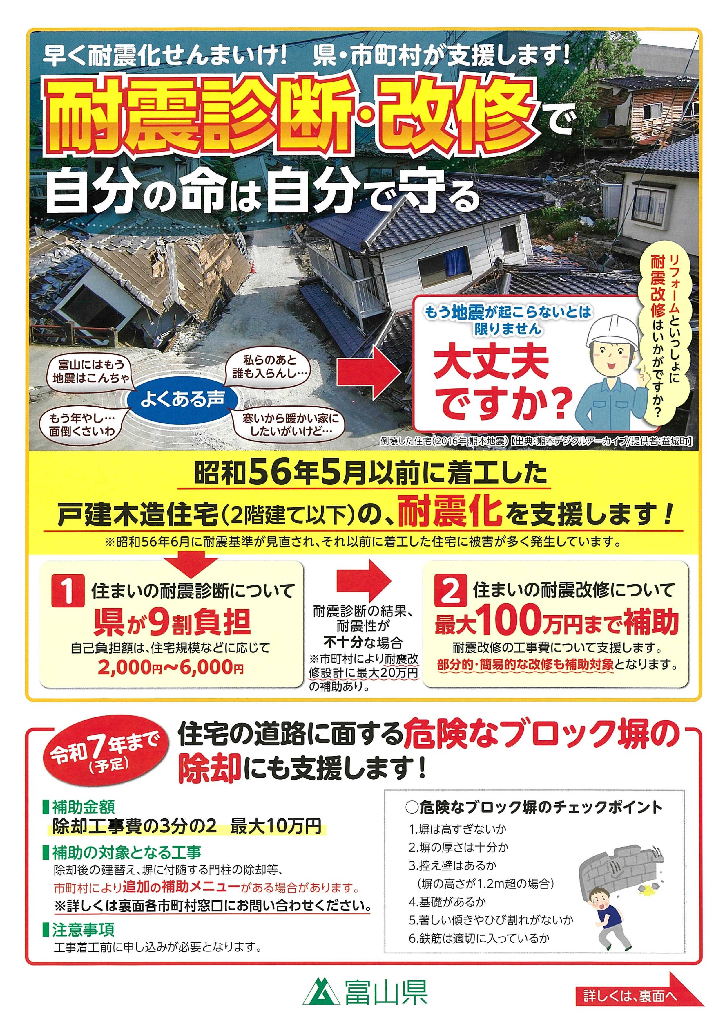
PDF: Toyama Prefecture – “Protect Your Life with Seismic Assessments and Retrofits!”
▶︎ Related Links
Toyama Prefecture – “Protect Your Life with Seismic Assessments and Retrofits!” (Informational Flyer) (Japanese)
Toyama Prefecture – Support Programs for Seismic Assessment and Retrofitting of Wooden Houses (Japanese)